Taroko National Park
Taiwan is a crowded island with not just people but also lofty mountains. What you don’t know is that this little high mountain kingdom also sets aside a huge area of lands for a diversity of different types of national parks. Among them, the most notable in the tourism of Taiwan must be the Taroko National park.

Precipitous Cliffs and Narrow Gorges
Traced back to Japanese era, Taroko is one of the three proposed national parks before the Second World War of Taiwan. The name itself is in fact derived from the Japanese romanization of the local appellation, which either refers to the area or the indigenous tribe residing on the soaring mountains to the west of the azure Pacific Ocean. Searching for gold, the Japanese colonial government built a gold prospecting road into the hostile terrain after conquering one of the most fierce tribes on the island of Formosa. The famous Highway No. 8 stretching into the mountains from the east to the west of the country is sort of planned ahead during this period of time. Meandering along the erosive Liwu River, visitors are always stunned by the awe-inspiring narrow marble gorge and the constantly-polished marble riverbed right beneath the road or the path. Thanks to the up-lifting forces from the thrusting tectonic plates under Taiwan, the depth of the Taroko Gorge has been extended and the sheer vertical marble faces along the river valley are able to bring more tourists than fallen rocks!
Taroko Gorge – into Taiwan’s Marble Mountains
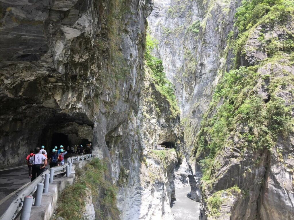
On the fourth day of the award-winning round-the-island tour product 5-Day Best of Taiwan: Sun Moon Lake, Taroko Gorge, Kaohsiung, Taitung, we’ll enter the world-renown Taroko National Park after basking in the sun along the azure Pacific Ocean coast. The land mass of this area used to be a huge patch of shallow sea with thriving coral reefs. After being twisted, heated, and kneaded by heavier rock layers on the top, many of the boulders along the valley are metamorphic, especially the marble rocks, which are known as metamorphic limestones. The eastern side of the island has been gradually pushed up the sea level while the continuous cutting force of the Liwu River keeps showing tourists how deep and precipitous the marble gorge can be. The length of the marble distribution along the river is just around twenty kilometers and the most condensed part of the marble gorge is stretching between the Swallow Grotto and Cimu Bridge. Most of the attractions included in this tour are lined along this magnificent section of the river valley.

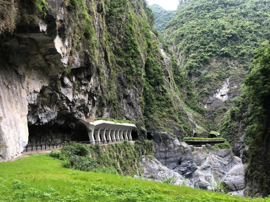
Swallow Grotto
Most tour members will be first welcomed by the beautiful section in the gorge known as Swallow Grotto. It’s rumored that visitors can witness a flight of migratory swallows here every summer catching insects in the air thanks to the gorge wind. I, however, often witness pacific swallows, barn swallows, and other species of martins along the valley without spotting hundreds of birds at one time as it is claimed. Nevertheless, this is absolutely a magnificent section of the gorge to find out how the eddies on ancient riverbed carved out holes on the rock face. It’s also said that if the opening of the “grottoes” faces down the river, they must be done by the gushing of ground water in the rock mass. This part of the gorge has the most grottoes on the cliffs so it features “swallows” and “grottoes”. What’s more, in the 1989 two-dollar stamp of Taiwan, the scenery used is exactly from this part of the gorge.
The traffic here along the way is always heavy and finding a parking space is as difficult as winning a lottery. Be prepared for extra walk if the tour bus driver couldn’t find a decent place to wait for the group. If this is the case, you’ll be able to spot another amazing section of the marble mountains, which is known as Zhuilu Cliff. This is a 1.2K long section of the deep gorge where you can place dozens of Taipei 101’s here without being detected from the sky above!

Central Cross-Island Highway
The Highway we use to travel into the marble mountains is as important as the national park. The construction of the Highway No. 8, as it is numbered in the road system of Taiwan, began in 1956 and completed in 1960. Less than four years of time, a highway crossing the harsh central mountain range is done with considerable doubt over nature limitation. The Taiwanese government, however, took an all-out effort to finish the nearly two hundred kilometer long cross-the-island highway out of economic and military reasons. The western media openly boasted this project and named it the “miracle highway”. Largely carved into the rock face and connected by some of the advanced steel bridges, this well-known east-west cross-island road is able to bring more and more domestic and international sightseers into this world of marvelous Mother Nature.

Silks Place Taroko in Tianxiang
The fourth day tour will come to an end after the tour bus carefully travels through the vulnerable gorge. The gorge is never a safe place and constant reconstruction is always on the go. The Edison Tours local travel agent, however, sees the accommodation in the gorge an invincible part of the arrangement in terms of the ultimate experience in the national park. Though not always the case to stay at this only five-star hotel in Taroko, group members do greatly appreciate this top choice at the western end of the marble gorge.

Situated on the old river terraces of the village named Tianxiang, this hotel has a glorious past when it was known as Tienhsiang Lodge, the only decent place to accommodate the president and high-ranking officials, including overseas celebrities and political heavyweights like Eisenhower. Called Tapido in tribal language during Japanese era, Tianxiang is the name of a national hero in Song Dynasty of Chinese history and adopted as a place name as opposed to the Japanese influences before the WWII. To your surprise, the little village has now a 7-11 convenience store though it’s not 24/7!

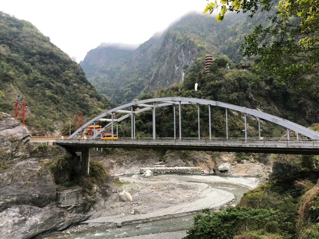
Cimu Bridge
After checking out, the group heads for Cimu Bridge first in the morning. The Chinese romanization “cimu” means loving mother because the ex-president Chiang Kai-shek and his successor Chiang Ching-kuo built pavilions in memory of their mothers respectively. The red cable-stayed-like steel bridge stands majestically at the confluence of Liwu River and Laoxi River. It’s said that the original bridge is made of white marble from here but was washed away during a typhoon in 1990. So, it’s nicknamed “marble bridge”. On the eastern end of the bridge, visitors can overlook a beautiful section of river bend, where most of the riverbed has been polished by rapids through millions of years. This is the scenery used by some online travel agents to sell tour products in Taroko or all over Taiwan. Instagram celebrities and the like love to come here to pose for their scenic photos with the white ornate marble lions on the bridge in the background.

Lushui Trail or Tunnel of Nine Turns Trail
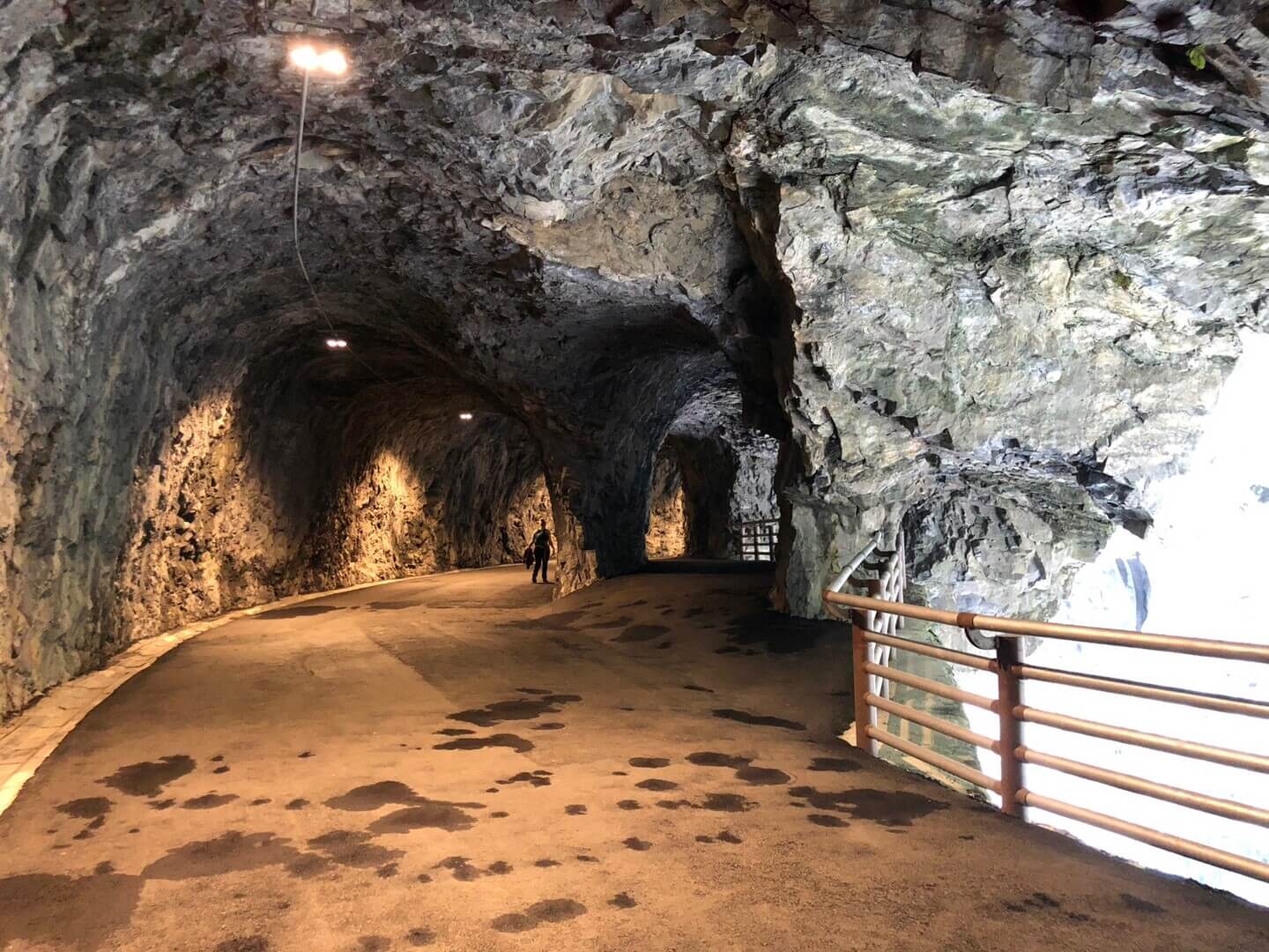
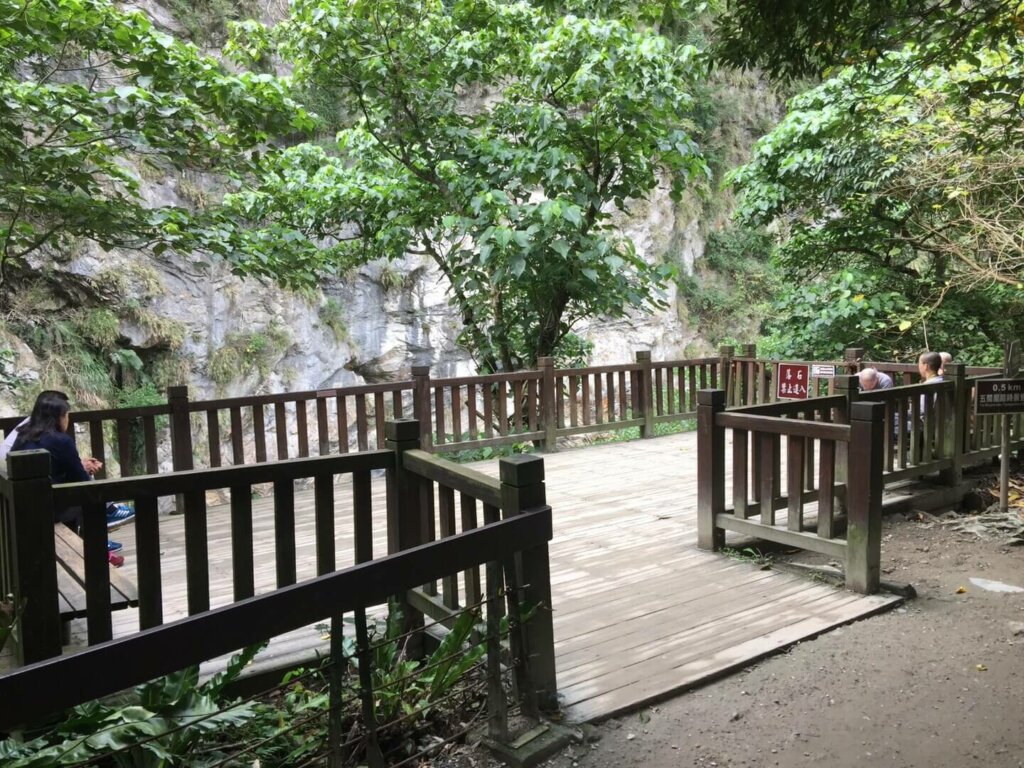
The itinerary, next, will take the group to Lushui Trail, which is part of the old Hehuan cross-mountain trail made by the Japanese authorities in 1930s. Soon after the colonial government conquered the ferocious Taroko tribe, they set up a couple of sentry posts in the mountains while promoting tourism in this area. The trail can either starts at Lushui, hence the name, or Heliu. It’s about one kilometer long and has suspension bridges and short man-made tunnels. The middle section is especially photogenic because it perches on the vertical rock face! The hikers can see layers of ancient river terraces as well as the stunning scenery along the river. This trail is, however, vulnerable to fallen rocks and earthquakes. For quite a long time, hikers couldn’t make it or could just walk the first few hundred meters and come same way back.

When this trail is not available, the group will always opt for the newly-opened Tunnel of Nine Turns Trail. A section of the old highway before 1996, this trail opened for visitors to walk on in 1998 but closed in 2010 when terrible accidents happened right here. It reopened in summer of 2019 after nearly a decade long reconstruction. Currently the opened section of the trail is only 700 meters and you’ll have to come same way back. This section of the old road has the same reputation as the Swallow Grotto, both of which are celebrated for the astonishing carved-in sections of the road on the marble cliff with narrow and twisted turns all long the way. The middle section of the trail is the “waterview” trail, which has transparent floor sticking out from the main path. You’ll probably find yourself even further into the gorge!
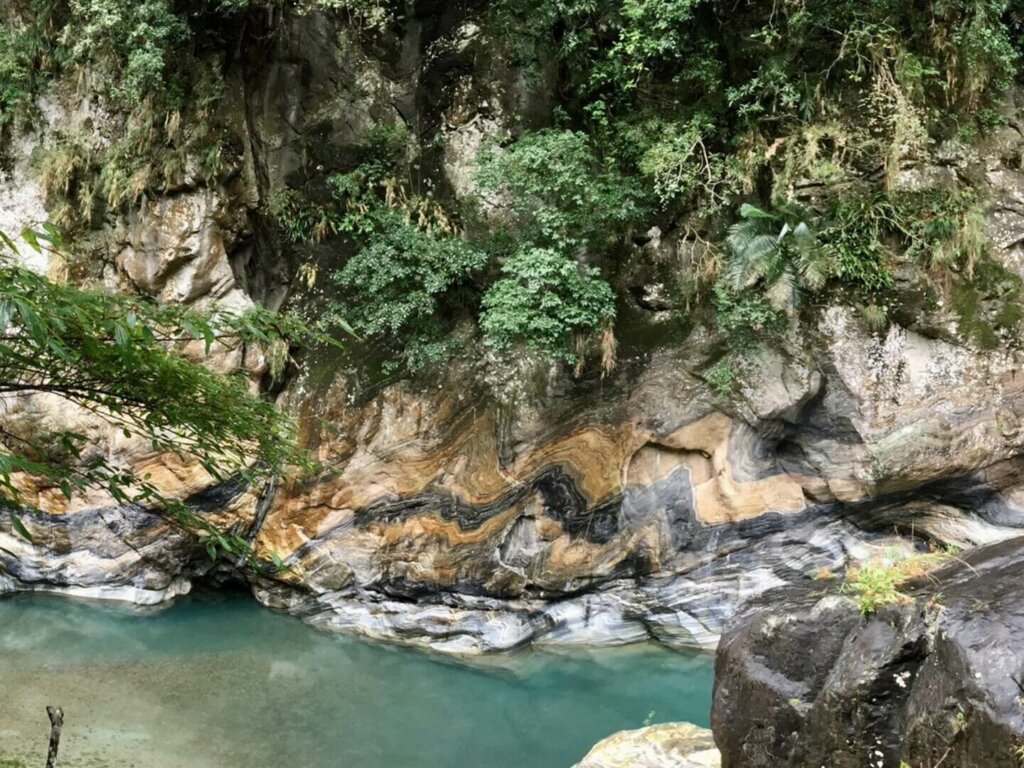
Shakadang Trail
This is one of the longest trails in Taroko National Park. The whole length is more than four kilometers one way but this itinerary only focuses on the most beautiful section of it, which is only one kilometer from trailhead to the observation platform. Shakadang got its name from Taroko language, meaning “molars”, after local tribesmen’s ancestors found the teeth from prehistoric people while setting up their villages in the area. Under Japanese rule, the Liwu hydropower plant was built in 1940, and an electricity road was created in order to maintain the pipes and dams into this tributary of Liwu River. When the national park was established, the trail was promoted as “mysterious valley” for tourism at the beginning and later, to respect the indigenous culture, as Shakadang Trail with the emphasis on the beautiful combination of metamorphic boulders and turquoise stream water. After walking for just about 600 meters, you’ll find, on the left, a high rock face with twisted folds like a huge mille crepe cake. Further down the trail, visitors can witness wave-like colorful folds just right above the river on the opposite site of the valley. When you arrive at a big wooden platform, the picturesque rock folds in front of you will wrap up your twenty minutes’ walk. Don’t forget, you’ll need to go same way back to where you started. The bus couldn’t come here!

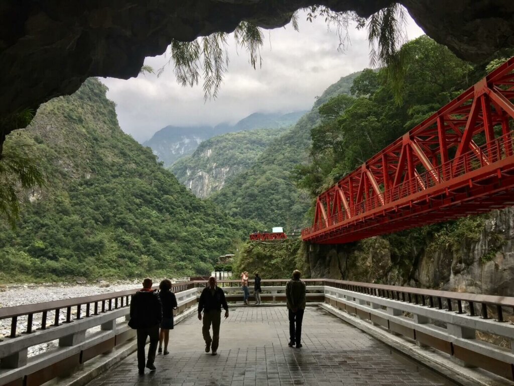
Eternal Spring Shrine
Further out of the gorge, the group will stop at the most recognizable landmark in Taroko Gorge – Changchun Temple, or, in English, Eternal Spring Shrine. This is a memorial monument set up to commemorate those “construction heroes” who sacrificed their lives to link the west and the east of Taiwan through hostile mountain ranges. The shrine is built right above a natural waterfall and, according to our traditions, the running water is believed to possess the power to soothe the spirits of the dead.

From the current road level, you’ll find a viewing platform right beneath the Chuangchun Bridge. That bridge span is actually part of the old road before 1958. To the right of observation platform, you’ll see a tunnel and, if you walk all the way to the shrine, as we normally do, you’ll be amazed by the formation of the marble path while going through a couple of narrow passages. The view from the shrine is wide and, to the right, you’ll see a towering gap of marble faces with the river cutting through. In the shrine, there’s a stone tablet inscribed with the names of the deified heroes. When the national park celebrated its 30th anniversary in 2016, the Google company even made a doodle of the scenery here to pay tribute to the world-renown Taroko Gorge!

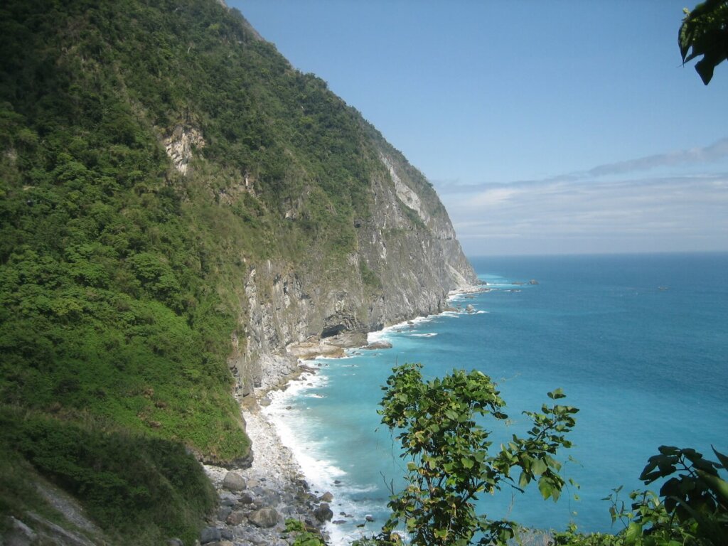
Qingshui Cliff
The tour will almost come to and end when we arrive at Qingshui Cliff, which is located at the southernmost end of the Suhua Highway but still in Taroko National Park. This is a perfect location to see the vertical precipice and rolling waves. Unlike the attractions along the gorge, this seaside stop overlooks the expansive Pacific Ocean and is right below the towering marble precipice. There’s a bigger viewing platform a bit down the road with a marble piece inscribed with the name “Qingshui Cliff” and “Taroko National Park”. If you haven’t done any of these photos, you’ll have to do it right here before heading for Taipei. Standing near the edge of the marble precipice, tour members will certainly keep the charming scene in mind while planning the next trip back here again!
Visitor Information
Opening hours
The attractions along the gorge are basically 24/7 except facilities and centers manned with public servants. The trails are, however, subject to reconstruction and repair due to constant earthquakes or fallen rocks. Better to check the official website before spending your holiday here.
Admission
No admission is needed to visit the Taroko National Park.
How to get there?
I was talking about the packaged tour, so the tour bus and guide will take you to the above attractions without hassle.
Useful Tips While Visiting
Too hot in summer?
The mountainous area here has microclimate and is always cooler and easier to find shade during visit. The lush green vegetation cools the air down quickly and easily, and the only heat you might feel is from the exhaust pipes of loads of tour buses and vans during high season!
Feeling hungry?
Today’s lunch solution will be shops and eateries near the south end of the 1.2 kilometer long Taroko Bridge, which was open in 2002. This area offers some decent choices plus two convenient stores and snack shops. Generally speaking, the group stays here for a while before taking on the Suhua Highway to visit the last stop Qingshui Cliff. The most preferred stop is a famous beef noodle soup restaurant but it frequently closes on Fridays.
Extra information
The gorge might be entirely shut when there’s a tropical storm on the way or when the Central Weather Bureau issues torrential rain warnings. The hotel tonight is not always guaranteed due to its limited number of rooms and the isolated location in the gorge. In order not to be stuck in the gorge, the tour members may have to accept the travel agent’s arbitrary Plan B or Plan C due to the severe weather and booming tourism in extremely high season.


